Ned Tibbits
21 hrs
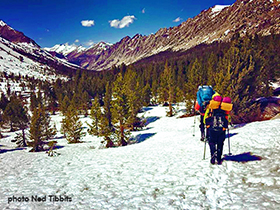
For all of you wanting to head into the Sierra in June, please consider this southern JMT trail conditions report for the end of May, 2016:
May, 2016 Southern Sierra Trail & Snow Conditions:
Snow Concerns:
Snowline:
- Southern exposures at about 10,500
- Northern exposures at about 9,500
Snow Composition:
- Consolidated hardpack in the morning to about 10-11:00am with a frozen crust and multiple layers of ice within the pack.
- After 10-11:00am, the snowpack softens allowing deep postholing, fatigue, and floundering.
Trail Conditions:
KM to Cottonwood Pass:
- The trail is dry to Dutch Meadow above Diaz Creek, then expect snow covering the route on all northern exposures the rest of the way per snowline details above.
Cottonwood Pass to Forester Pass:
- Chicken Spring Lake (CSL) is beginning to open up, otherwise it is frozen and its outflow is limited.
- The route out of CSL is across a southerly exposed ridge, so expect a mix of snow and dry trail.
- There is a small seasonal creek running at 753.25, then no water on-trail until Rock Creek, 760.
- Rock Creek crossing is best accomplished on two logs just upstream of the summer crossing spot.
- Carry a liter of water at all times in the Sierra.
- Guyot Creek is flowing at 762 and the route to the pass is dry.
- The route down from Guyot Pass is snow covered, so you can follow the trail or go straight down and across the meadow on snow to connect with the trail on the other side.
- The descent to Whitney Creek in lower Crabtree Meadow is snow covered, so be careful. It is steep in this area (765.5-766). It is recommended that you follow the boot-pack route straight down from the overlook rather than trying to follow the summer trail�s switchbacks down to the wooden stock gate below. Prepare for deep postholing if you�re there in the afternoon!
- Whitney Creek�s crossing is a shallow walk-through just above the summer crossing spot.
- The ascent up to the JMT junction is steep and dry on a southern aspect.
- There is a little seasonal creek at 768.25
- The descent to Wallace Creek is snow covered and steep, so be very careful if you�re there in the morning when the snow is hard. Use hiking crampons or go straight down this slope.
- The crossing of Wallace Creek is deeper and faster than that of Crabtree, so be careful! If you�re in there in the morning, beware of icy rocks and logs that you might slip on and fall into the creek. Best to deepwater wade. Wear the proper footwear to protect your feet!
- The route to Wright Creek is dry on southern exposures, but snowy at the creek itself.
- The crossing of Wright Creek is fast and deep, but narrow. Deepwater wade with proper footwear and balance techniques!
- The route from Wright to Bighorn Plateau is across a short, southwest facing washboard of creek headwaters, so expect patches of snow turning into continuous snow all the way up. The lake on Bighorn is frozen and it is often very windy there.
- The route across the western exposure of Tawny Point is drying out, but still is largely snow covered. The bear box at 774 is open.
- The crossing of Tyndall Creek no longer has snow bridges anywhere to the north, so you might as well cross at the summer crossing spot. It is similar to Wallace, so prepare for a cold, fast, moderately wide wade taking balance and footwear precautions! Good camping on the other side in preparation for your early morning (0600) ascent to Forester.
- Go up to Forester Pass on very early morning snow to avoid serious and unending postholing if you�re there after 1100! Use your hiking crampons when on anything steep.
Forester Pass to Onion Valley trailhead:
- Forester faces south, as do most of your high Sierra passes, so it will have a lot of crusty, freeze-thaw snow on it, so expect to need for your personal safety hiking crampons and two poles for balance, one of which should be a self-arrest pole in case you slip and fall.
- Make your own switchbacks up its lower, 20-degree slopes to where you can get on the summer trail. Maintain your balance at all times and be very careful about holding an edge on your shoes to the crusty snow. Microspikes may not work on traverses, but may work going straight up. Do not go up the chute, itself!
- The causeway across the ice chute (45-degree) was made again May 8th by Ned Tibbits, so it should give you safe passage across.
- The westside switchbacks after the chute should be largely free of snow, but this ascent will end in a short, steep wall of snow covering the trail upon which are toe-holds you can stand in to go straight up to top-out on the pass. If this looks too scary to you, go back half a switchback and ascend up a ribbon of rocks, then walk out to the pass on snow.
- The descent of Forester�s northside follows the ridgeline going northwest which terminates in cliffs down which the summer trail switchbacks. Your best descent is to follow this ridgeline partway, then glissade down to the lake below, maintaining your seated balance and speed so you do not tumble and need to self-arrest to stop.
- You can follow the snow-buried summer route from this lake at 781 or you can make your own bee-line route down to the Center Basin Creek crossing (784), which you can see coming in from the right, below you at treeline.
- The trail down to Vidette Meadows is full of patchy snow, but following the summer trail from 785 on down is not too difficult, just keep photogenic Bubbs Creek to your left. The Vidette area is drying out and has good camping.
- The climb to 788 is dry, but thereafter you will hit snow at the creek crossing. Stay to the left of the creek on the rest of your ascent to the Bullfrog Lake jct..
- The lower route by Bullfrog and Kearsarge Lakes is covered in snow, but the high traverse to Kearsarge Pass is largely dry (at least initially), so go up another 500 feet via switchbacks to the unmarked Charlotte Lake jct. and continue up a small drainage after a little meadow to find the upper Kearsarge trail. The latter half of this traverse can have some steep snow ascents and traverses, so be prepared to edge-in with your boots.
- The route from Kearsarge to Onion Valley is steep and often snow-covered, but many people will be going up and down this trail starting Memorial Day Weekend, so it is pretty easy to follow!
Safety Gear Recommendations:
1. Hiking crampons like the Kahtoola KTS or K-10 for traction and hold on steep, crusty snow traverses.
2. Self-arrest pole like the Black Diamond �Whippet� so you can maintain your balance with a pole and have a self-arrest device in your hand at all times.
3. Medium weight hiking boots that are over the ankle for edge control on traverses and increased traction.
Strategy Recommendations for Safety:
1. Do the high passes as early in the morning as possible so you will be walking on hard snow surfaces rather than postholing.
2. Camp close to the high passes so you can get up and over them and down to dry trail before �postholing time.�
3. Wear your crampons whenever on steep, hard snow, however briefly, because a slip-and-fall could be your last.
4. Whenever you might risk a fall on steep snow, always have a self-arrest tool in your hand (ice axe or Whippet). They can�t save your life tied on the back of your pack!
5. Cross the big creeks in the morning when flow rates are lower.
6. Get to Sonora Pass soon so you cross the long, thus big creek drainages before they swell in the Sierra thaw (once it starts, indicated by above freezing nights and very warm days).
7. Remember, you can walk on top of snow as long as it is frozen. It doesn�t matter how deep the pack is. Once it stops freezing every night, after the thaw starts, you�ll have to start hiking very early in the morning to utilize what cold you got during the night.
8. If you want to avoid snow and flip up to someplace drier, consider the lowland of NorCal, especially between Sierra City and I-5. Lassen still has lots of snow at present. Oregon will still have lots of snow into July. Washington will have steep snow into August.
9. Get to Manning Park before the powder snow flies, about mid-September, because it can stop you in your tracks! Contact Andrea Dinsmore in Baring, WA, for August/September expected conditions!
May, 2016, Observations:
1. The nights are still below freezing, so don�t let your footwear get wet as they will freeze at night.
2. Rotate dry socks through wet shoes as you hike, even on snow, to try to get your feet dry.
3. Hang wet socks on your pack to dry in the sun (if you have sun!).
4. Avoid trenchfoot by making sure your feet dry out somewhere along the line.
5. Trail Runner footwear twist too easily and have too soft an edge to grip hard snow on a steep traverse. Do not use this type of shoe under current snow conditions throughout the Sierra. Microspikes nor hiking crampons do not help this design hazard.
6. Boots that do not twist and have sharp edges and deep lugs work wonderfully by cutting/stomping into steep, snowy traverses to keep you from falling or slipping. Microspikes help this design a little, but hiking crampons compliment and function best.
7. Days and nights are warming, so creeks will be rising and flowing faster unto creating �whitewater� conditions at creek crossings.
8. If you find yourself postholing continuously and you still have a long way to go, consider camping and doing the rest of the route very early the next morning. Postholing is exhausting and can jeopardize your safety by depleting your energy and strength reserves.
9. Creek crossing late in the day will be nastier due to higher water volumes and flow rates. If a crossing at this time of day looks too rough for you (I�m thinking of the South Fork of the Kings River), camp right there and cross in the morning when the flow is lower.
I hope this report helps you make wise decisions and keeps you safer while you enjoy our awesome wilderness!
Ned Tibbits, Director
Mountain Education, Inc.
www.mountaineducation.org
ned@mountaineducation.org
Mission:
"To minimize wilderness accidents, injury, and illness in order to maximize wilderness enjoyment, safety, and personal growth, all through experiential education and risk awareness training."